

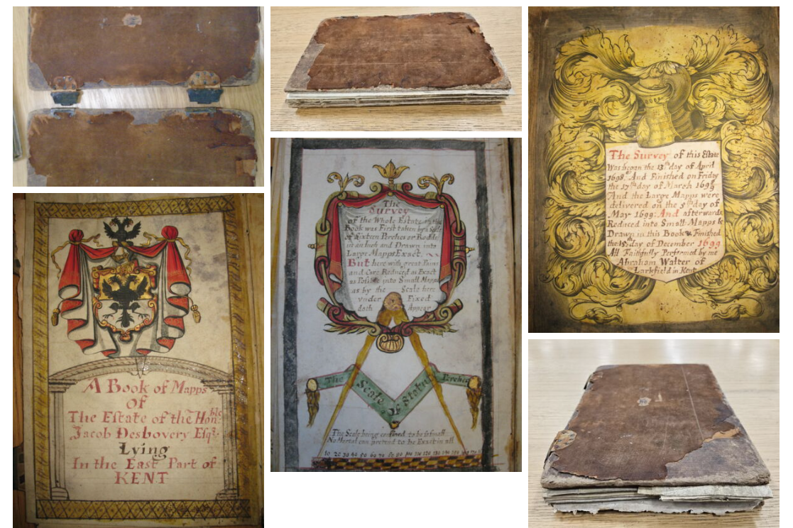
We have been delighted to work with the New Folkestone Society on their project to conserve and digitise ‘A Book of Mapps of The Estate of the Hon[oura]ble Jacob Desbouvery Esq Lyong In the East Part of Kent’. (ref 1946/2/3E/1) held in the archive collection of the Earls of Radnor at the Wiltshire & Swindon History Centre. The project received a grant from the National Manuscripts Conservation Trust. Find out more about the inspiration behind the work in a guest blog:
A story of how I came to be interested in Abraham Walter’s book of maps and what has resulted from curiosity.
By a trustee of the New Folkestone Society.
St Eanswyth our local Saint, was a member of the Kentish Royal Family.
Her Mum and Dad were, King Eadbald of Kent, and Emma, a daughter of the King of the Franks. A French Connection no less.
Her Granny and Grandad were King Ethelbert of Kent and Queen Bertha. It seems she never married, and in those days, I am told, Dads who were Kings, could offload in marriage, their offspring wherever they wanted.
We might assume she was a strong independent young princess and sensibly didn’t fancy marriage. Her Dad set her up as Prioress in a Priory in Folkestone, possibly to keep an eye on his assets and investments.
He wasn’t consistently Christian; however, her Mum appears to have been.
The Priory has disappeared over the cliff but a church bearing her name and her remains is still there in an area called the Bayle.
Local legend and the miracle that sainted her, has it that Eanswythe made water run uphill to serve the town and the Priory.
Some years ago, an effort was made by local archaeologists and historians, with the help of the all-important funding and volunteers, to find out if this miracle was indeed true and that’s how I got involved, as a volunteer.
Copies of old maps of the area showed the origin of what was famously known as St Enswythe’s water, which ended up in the pond on “The Bayle” in the centre of the town.
On a trip to Chippenham, out of curiosity, I visited the Wiltshire Archives, based on the thought that, as The Earls of Radnor, who owned and still do, a large part of Folkestone, lived down the road in Longford Castle, it might be a place to find some old maps.
Our local records had revealed a set of 12 maps dated 1782, commissioned by the then Earl of Radnor denoting all the properties in Folkestone that he owned. These were in black and white.
In the Chippenham archives I discovered the original maps in colour in almost perfect condition in a ledger along with an index to all the properties contained therein.
The index gives who lived in the properties and whether they were residential or commercial and what rent they paid for the area occupied and much more: an interesting social record of life as it was at the time and before the railway and modern development came to the town.
I also discovered the “Hundred” maps/plans, dated 1798, again commissioned by the Earls of Radnor, I was able to see who owned the lands and fields around Folkestone and what was grown on them. I found the watercourse Eanswyth had reportedly made to run down one hill and up another into a pond to service the Priory, and presumably a very grateful town. However, it also indicated there was a well not far from the pond. So, one starts to wonder, why the Pond?
There were various references to St Eanswyth’s water course and its source, which joined up with another stream and eventually arrived in the Town and subsequently called the Town Ditch. Many a legal tussle has taken place over who could use the water until it was finally taken on by the local water company.
Subsequent research by today’s experts has revealed that before Eanswyth came on the scene, the Romans occupied the area. The conclusion has been reached that water running uphill was probably an optical illusion.
The Romans were famous for engineering water to go where they wanted it. And various generations throughout the following centuries built on their knowledge, including Eynswythe’s generation. This apparent miracle gained her a Sainthood, and possibly a healthy income for the Priory from visiting pilgrims to drink the miracle water that ran uphill.
No miracles I am sorry to say but over the centuries, a clever feat of engineering. The town ditch is still there but buried under lots of houses and it still serves a pond on the Bayle, the water from which was diverted down the medieval streets to the harbour, to clean them, including the local slaughterhouse, still there and as far as we know, limited to pigs only.
There is still a building on the corner of the old High Street, just off The Bayle, which was a butcher’s and has the casts of two pigs’ heads attached to the outside wall.
Lots of local lads used to be dumped in the pond on their Stag night. Not allowed now.
In Victorian times, in the church, a casket was discovered containing some bones. It was assumed that these had been hidden from Henry and Cromwell in the wall during the Reformation and taken to be the bones of St Eanswyth. So, part of all this research over a period of years has been to prove, with modern technology, that they were indeed her bones. All that stuff was left to the scientists to find out.
It was known approximately when Eanswythe was born and when she died. It was assumed that any old bones would not have been hidden so carefully, so they took a chance and gained funding and permission from the “Clergy” to get them tested. Not an easy thing to do by any means.
However, it turns out that they did indeed fit the period when she existed and her age when she died. The tests turned out to be over ninety five percent accurate and so we can assume – with some confidence – that we do indeed have a royal saint’s bones in our church. A modern casket has been commissioned to put them in and they have been re-interred in the church wall where they were originally found. St Eanswythe is back in the wall in brand new casket.
All that is what got me going on research and the history of the town. I arranged a small exhibition in the church based on the 1782 maps, just before lockdown. It gives a detailed look at the properties in a small area called The Bayle and access to the index relating to it. The Bayle sits next to the church and is one of the oldest parts of Folkestone. The buildings are numbered on the maps and the numbers in the index show who lived there, what the building was used for, how much rent they paid, what the acreage was etc, whether they rented a garden. Some of those gardens still exist and, Eanswyth’s water still runs in to the pond.
The maps are stunning, and I am hoping to team up with others on expanding the information in all twelve maps with the help of other amateur researchers and historians.
All this of course, opens up a connection from Folkestone to the Earls of Radnor, and the archives in Chippenham.
Among the above volumes of maps, I found the original book of maps by Abraham Walter, of this area of Kent, commissioned by the ancestor of the current Earls in 1698, and completed in 1699.
Folkestone historians knew of this book of maps but few had realised it was in Chippenham. It is a unique record of this part of Kent, in colour, gilded and again with an index of ownership, and uses etc.
As it cannot be removed from the archive, I and the New Folkestone Society have undertaken a project to have it conserved, digitised and a replica made for Folkestone, so that historians and researchers can appreciate its uniqueness and the information it contains.
Watch this space as it is an ongoing project.
New Folkestone Society
Share this post
About Us
Research Tools
What We Do
Contact us
Wiltshire and Swindon History Centre
Cocklebury Road
Chippenham
SN15 3QN
E: heritageadmin@wiltshire.gov.uk
T: 01249 705500


