

Sherston is first mentioned in 896 ‘Scorranston’, a name which had by the time of Domesday (1086) evolved into ‘Sorstain’ representing Sherston Magna, and later in the Medieval period the name appears in its present form. One theory as to the origin of its name suggests that it is derived from the Old English ‘Scora’, meaning a steep slope or cliff, and ‘stan’, meaning a stone or rock.
It is a village with a fascinating, if somewhat underexplored, archaeological heritage. The most notable piece of fieldwork is the late 1980’s rescue excavation of a small Roman villa on the north side of the village close to Vancellettes Farm. Recent geophysical survey here has also hinted at a prehistoric feature on the same site.
The Church of the Holy Cross in the centre of the village has a north arcade which dates to the 12th century. It is probable however that there was originally a Saxon church on the site as it is mentioned in the Domesday Survey. It has an exceptionally large churchyard for a church of its size; a likely indicator of former importance.
There is evidence for a deserted medieval settlement on the eastern side of the village at Easton Town is referenced as “Estentowne” in reign of Henry VIII. This site was first plotted from aerial photographs which showed a possible Holloway, house platforms and quarry pits. Geophysics and an earthwork survey undertaken in 2009 identified two sunken trackways, a possible house platform and an area of quarrying.
In July 2023, together with my HER colleague Charlotte Godsiffe, I had the privilege of leading an archaeology walk around Sherston as part of the Council for British Archaeology’s Festival of Archaeology.
One of the many intriguing aspects of the archaeology of Sherston is the bank and ditch earthworks which comprise the only Scheduled Monument to lie within the parish of Sherston.

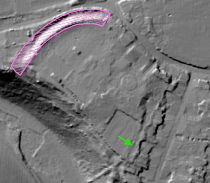
The earthworks (outlined in pink above) lie between Manor Farm and Sherston Primary School on the western side of the village. The earthworks, which lie on privately owned land, can be seen from a public footpath which passes to the south or from the road immediately to the north. Survey work undertaken in 1979 recorded a profile across the extant bank and ditch indicating a defensive profile with 3.8m between the base of the ditch and the crest of the bank. This remains the only known investigation of these earthworks.
This location is significant as the south-western end of the earthworks lie immediately adjacent to a steep, easily defensible slope leading down to the Sherston Branch of the River Avon. Indeed the location and alignment of the bank and ditch suggests it may have once formed part of a defensive arc protecting the area now occupied by Manor Farm.
However this interpretation of the earthworks is somewhat speculative given the lack of an easily identifiable return to the east of Manor Farm. It has also been suggested that the earthworks may relate to others shown on the First Edition Ordnance Survey map of 1886 (see below) in the area now occupied by the recreation ground to the west of the church. Sadly these other earthworks were levelled during the creation of the recreation ground in the immediate post-war period. Even allowing for the vagaries of late 19th-century earthwork survey, the form and alignment of suggests the two sets of earthworks are unlikely to be related.

The earthworks were considered further in an Extensive Urban Survey (EUS) of Sherston undertaken in 2001. (This can be downloaded from the Archaeology Data Service and is one of a series of 34 such surveys of the historic towns of Wiltshire.) The author noted that it was possible that the line of the earthworks may have continued underneath the current town. It was suggested that a narrow rectangular field (see above, green arrow) depicted on the 1st edition Ordnance Survey map and forming the western boundaries of properties fronting onto Back Street (now known as Cliff Road) may denote an eastern return of the feature. The width of this field being similar to that of the extant earthworks and also terminating at the top the steep slope leading down to the river.
Modern technology, not available at the time the EUS was compiled, can lend further credence to this view. Existing tree cover means modern aerial photography is of limited use. Recently available Lidar coverage of the area however shows a slight linear depression (see below, green arrow) correlating with that of the rectangular field. Could this linear depression indicate the partial survival of a defensive ditch?
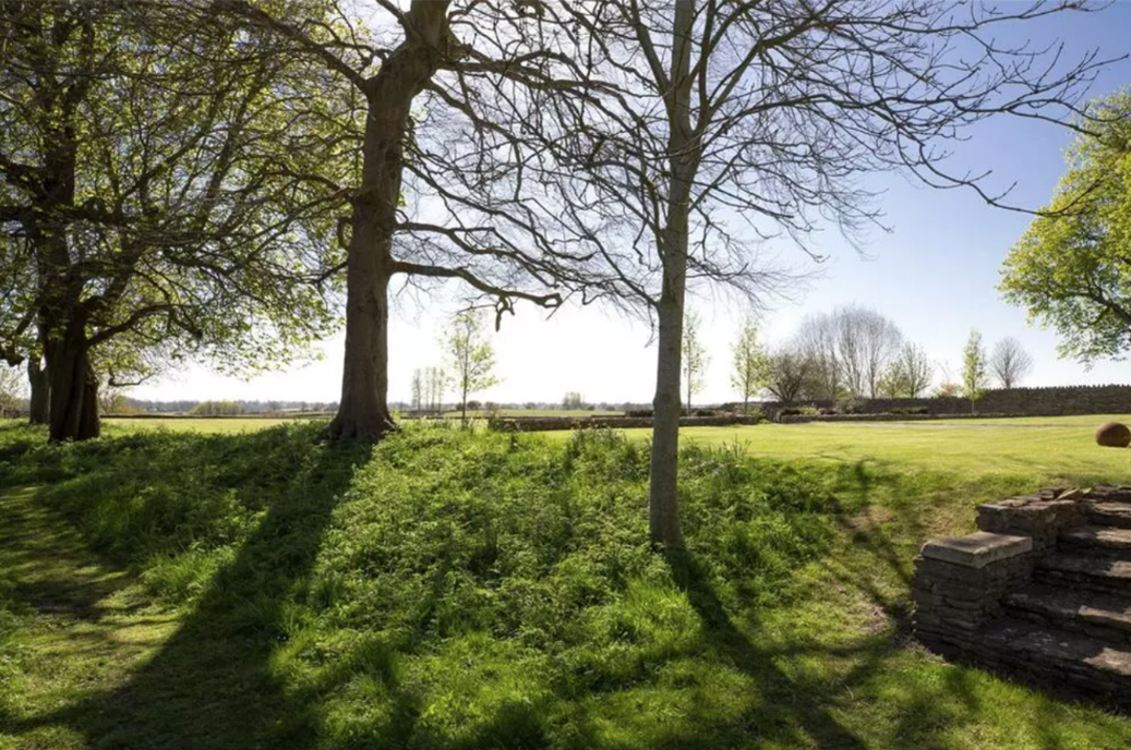
The photograph below is taken from roughly the northern end of the narrow rectangular field referenced above; a linear depression being clearly visible running alongside the line of trees.
Photograph from onthemarket.com
Given the probable south-eastern return of the bank and ditch earthworks and the location of the feature at the top of a steep slope, a defensive function therefore seems entirely plausible. As there has not been any known intrusive fieldwork undertaken on the earthworks, dating it is a bit trickier. The western extent of the 13th-century planned settlement defined by Back Street (Cliff Road) may have respected an earthwork still extant at the time. It is also possible that the slight change alignment of Court Street respected an extant earthwork.
Parts of the house at Manor Farm date to the 17th century making it a likely location for the post-Conquest manor. Could it be that the earthwork, although as yet undated, represented an attempt to fortify the manor during a period of upheaval such as the Anarchy of the 12th-century? A Wiltshire parallel for this can be found at Downton Moot in the south of the county where a temporary defensive work was rapidly established and then destroyed when peace prevailed. Might the partial earthwork circuit at Sherston have suffered a similar fate?
What could tell us more about the earthworks? Perhaps the first step would be an evaluation trench across the earthworks to learn more about their date and form of construction. Being a scheduled monument though, this would the require the consent of Historic England. Targeted trial trenching along Court Street and along the line of the projected eastern return of the earthworks would help identify any continuation of the ditch in particular. A similar approach on the south-western side could identify a palisade or similar where the steep slope leading down to the river may have made a bank and ditch superfluous. Geophysical survey of the gardens around Manor Farm would be of use in identifying structures only surviving as sub-surface remains.
For the time being though, the earthworks remain both enigmatic and intriguing.
Tim Havard, Assistant County Archaeologist
Share this post
About Us
Research Tools
What We Do
Contact us
Wiltshire and Swindon History Centre
Cocklebury Road
Chippenham
SN15 3QN
E: heritageadmin@wiltshire.gov.uk
T: 01249 705500


