

The Route That Never Was: Conserving an Extraordinary 1834 Railway Map
Few documents capture both the ambition of the railway age and the uncertainty of its early planning quite like this extraordinary six-metre-long map. Created in 1834, it records a proposed railway line from Basing to Bath that promised to connect communities across southern England, yet was ultimately never built. More than a fascinating glimpse into an alternative transport history, the map is also a remarkable archival object in its own right. Recently conserved, it offers an opportunity to explore not only a railway route that never came to be, but also the specialist work involved in preserving such a unique document for future generations.
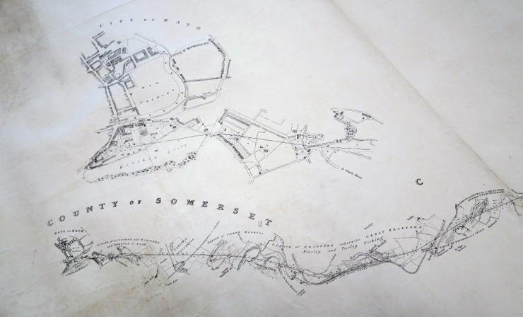
A1/371/3L Basing and Bath Railway via Shalbourne and Bedwyn (1834)
The Forgotten Rival to the Great Western Railway
This long map shows the proposed train route branching off from the London and Southampton line at Basing in Hampshire through Newbury, Shalbourne and Bedwyn in Wiltshire then continuing on through Devizes, Trowbridge and Bradford-on-Avon to terminate at Bath. Despite being meticulously designed to support residents and tradespeople of smaller towns between Bristol and Southampton, as a quick way to transport goods and customers coming in and out of both ports, the route was never built. It instead missed out to a more direct “Northern” alternative route of the Great Western Railway which eventually won the bid for the definitive connecting line from London directly to Bristol through Reading, Swindon, Chippenham and Bath.
The first proposal of a railway between London and Bristol was made in 1824 suggesting a capital of £1,500,000 in £100 shares but there were very few developments on this for the next seven years by which point the cost of the tracks alone had been estimated at £2,800,000. A Bristol Committee recruited an engineer to conduct a detailed survey of the land between Bristol and London, one Isambard Kingdom Brunel and land surveyor and valuer, W. H. Townsend. But it took another 4 years for the final iteration of the Great Western Railway Bill to be passed taking 57 days to be read and debated by the House of Commons only to be thrown out again by the House of Lords in 1834 due to the late submission of a rival bid by The Southampton Railway Company.
At the Great Western Railway House of Lords debate of 27th August 1835, Lord Privy Seal, Colonel James Mackenzie, 1st Baron Wharncliffe, said at the hearing that “The real truth was, that this was a contest […] between two rival companies.” And that he had “heard evidence in the Committee upon the subject of the Bill for forty-one days, having heard speeches of counsel, one of whom spoke for eleven hours”. He went on to propose that The Southampton Railway Company’s rival Basing -Bath line against the GWR was unsubstantiated, unsupported and unpopular with locals:
“The capital required was 1,000,000l. while the whole amount subscribed was only 350,000l, […] by people in Manchester and Liverpool”. The Basing-Bath line also met with opposition from the Avon Canal Company. Due to its very similar path across Wiltshire, it would be in direct competition for freight transport. Arguments erupted over many and varying engineering, economical and design obstacles. In contention was the topographical gradient and fabric of the earth, the destruction of valuable farmland, population sizes of the proposed destinations, connections that would help trade and travel with Ireland and even fears over the proximity to Eton School provoking “the great evils so much dreaded” of giving school boys too much freedom to make mischief. In the end Brunel’s survey of the land was deemed a far better prospect for the railway being a flatter and straighter line that was nicknamed ‘The Billiard Table’ and created an economic boost to the ancient market towns of Wiltshire.
How different might the social and industrial landscape have looked if the ‘Southern’ line was chosen over the ‘Northern’? The ambitious and daring feat of engineering that was the cutting of the Box Tunnel made history as the world’s longest railway tunnel when it was completed in 1841. Swindon was turned from a town of 2500 people to a bustling city as the host to the GWR headquarters, marking the end of the flat route from London and the beginning of the long gradual incline to Bristol. Chippenham was a temporary terminus during the building of the Box Tunnel bringing major trade and traffic through the town and has remained a key destination on the GWR to this day. One can only wonder if Basing and Bedwyn would have undergone similar transformations.
A Conservation Challenge
Even after more than eight years at the Wiltshire and Swindon History Centre (WSHC), I am still surprised by the extraordinary items that pass through the conservation studio.
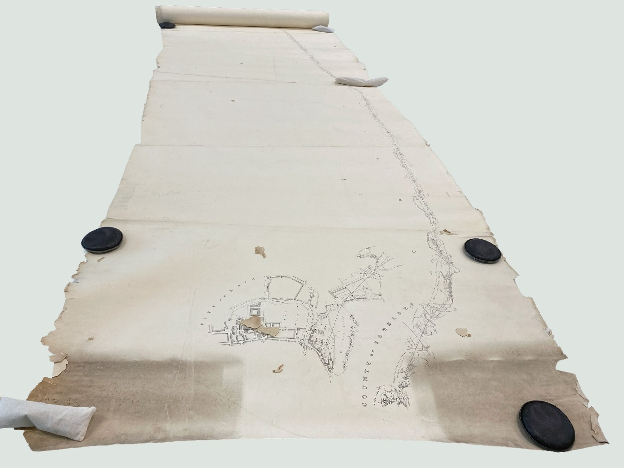
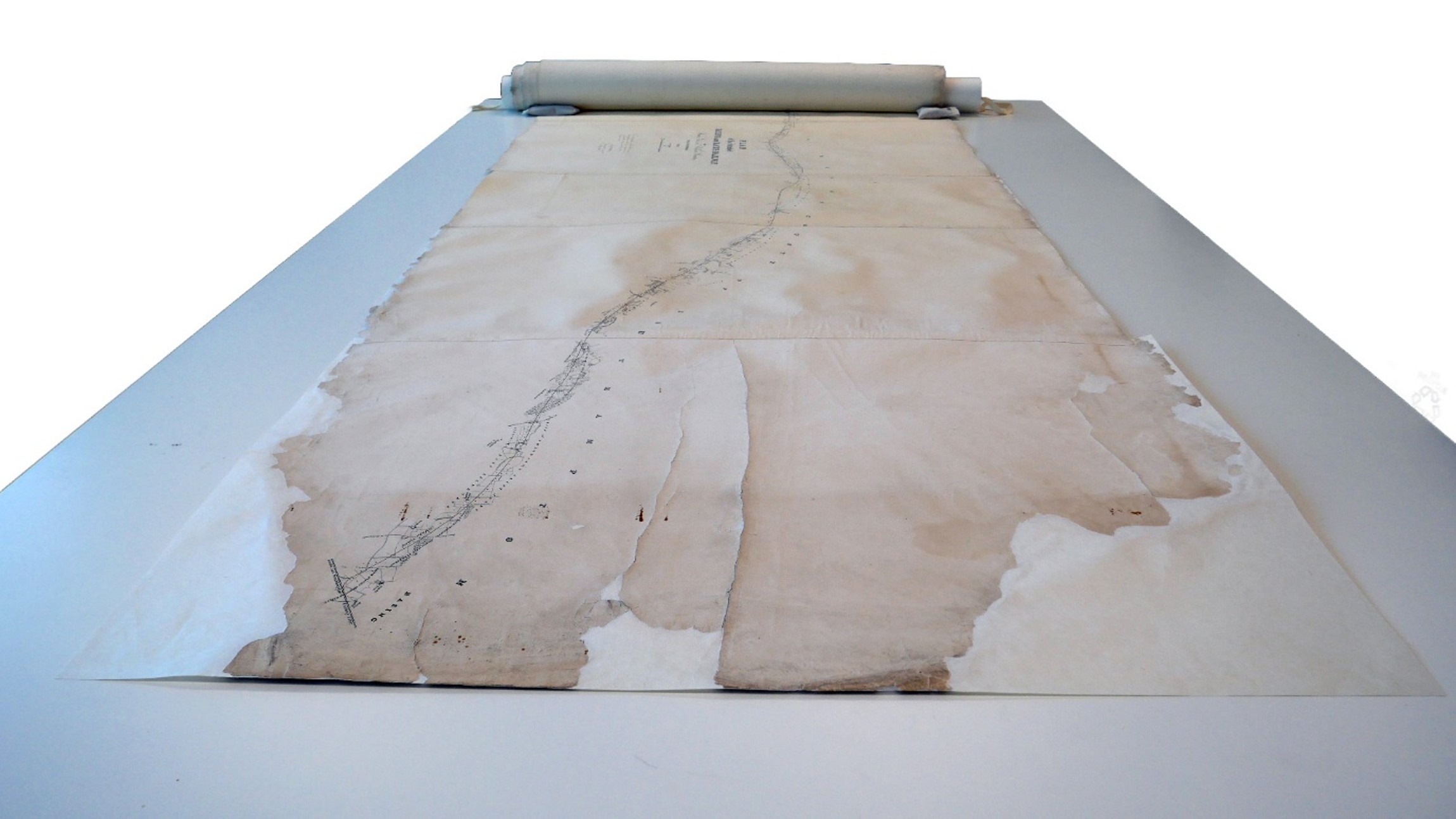
This remarkable map measures more than six metres in length and is made up of multiple sheets joined together. The map’s size was only one aspect of the challenge. Unlike a standard rolled map, it follows the curves of the proposed railway line, with sections joined together at different angles. This means the map is far from straight and difficult to roll evenly.
Years of storage in rolled form, combined with frequent handling, had left the edges heavily damaged. Small tears and losses could be found along almost the entire six-metre length. The paper itself is thick but had become brittle around the edges, causing many fragments to break away over time. Where detached pieces remained with the map, I reattached them whenever I could identify their original position. Fragments that could not be placed were preserved separately in an archival envelope within the storage box.
The map was also covered in surface dirt, with one end showing especially heavy accumulation. The most severe structural damage was found on the end sheet, where large tears made handling increasingly risky.
Cleaning and Repairs
The first stage of treatment was careful surface cleaning of both sides of the map.
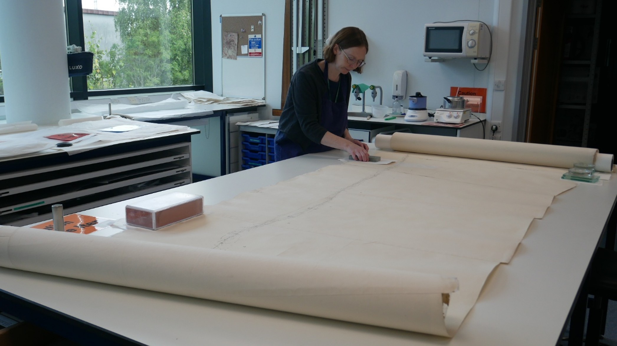
Fortunately, the map’s sectional construction made the process more manageable. I worked through it in stages, unrolling three sections at a time, cleaning the front and back before moving on to the next portion. This approach also allowed repairs to be carried out systematically.
To stabilise the numerous edge tears, I applied medium-weight conservation tissue to the reverse using wheat starch paste. This secured weak and detached fragments while providing essential support.
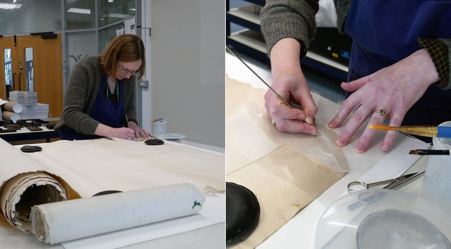
Under normal circumstances, I would also infill missing areas with paper of a similar weight and appearance. However, given the sheer length of the map, infilling every edge loss would have added a considerable amount of time. The support tissue alone provided sufficient reinforcement while also acting as a visible reminder that the edges remain fragile and require careful handling.
Treating the Most Damaged Section
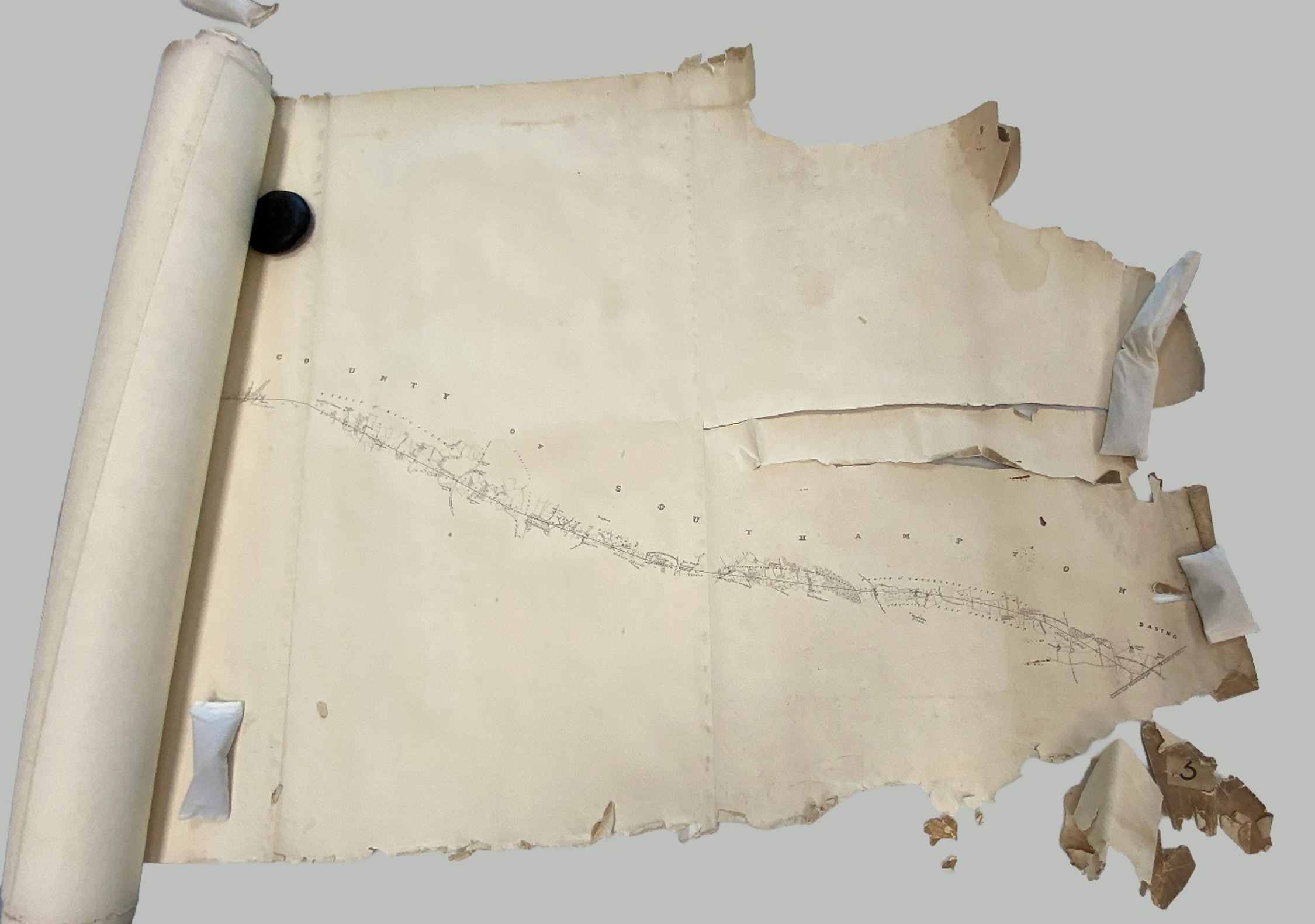
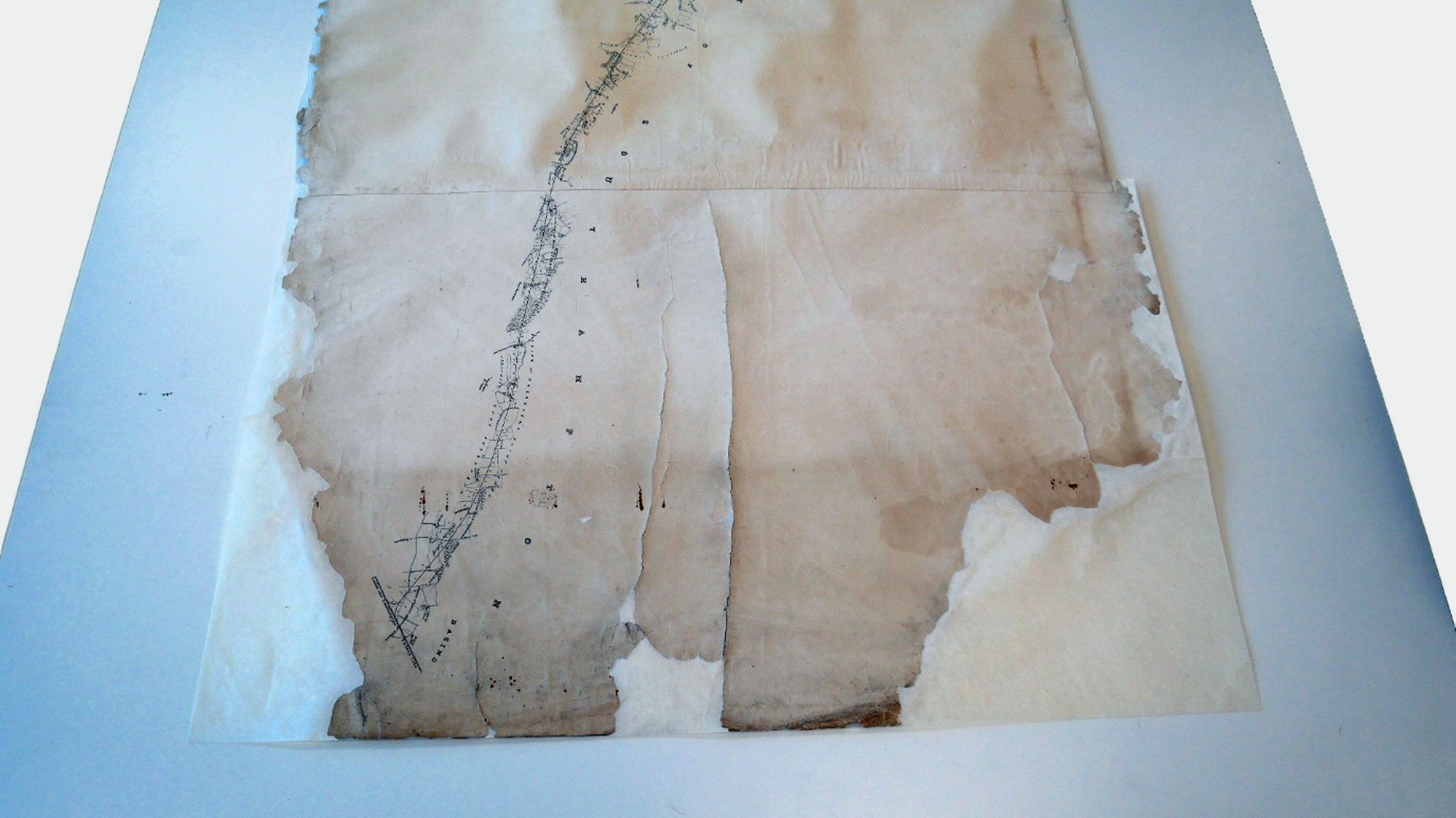
The end sheet of the roll required a more extensive approach. Because the damage was significantly worse than elsewhere, I temporarily detached the sheet at its original join to allow it to be treated safely and effectively. The sheet was first washed before receiving a full lining on the reverse. Washing helps to flatten the paper as well as removing ingrained dirt. A full lining was necessary because the tears were so extensive that localised repairs would not have provided enough long-term support. The lining tissue reinforced the entire sheet, allowing it to withstand handling far more effectively.
Once lined, I repaired and infilled the areas of loss where additional strength was needed. After several weeks of drying and pressing, the treated sheet was reattached to the map.
Repairs Built to Last?
Rolled documents present a particular challenge for conservators. Any repair is subjected to repeated stress each time the document is rolled and unrolled, which is why flat storage is generally preferred whenever possible.
Throughout treatment, I was repeatedly rolling and unrolling repaired sections as I moved along the map. This provided an opportunity to monitor how the repairs responded to use. Overall, they performed well, although a small number required additional adhesive reinforcement.
No conservation treatment can make a fragile document indestructible. However, these repairs have significantly improved the map’s stability and should prolong its life for future researchers. As part of the archive collection, the map can also be monitored over time and further adjustments made if necessary.
A Better Home
The final stage of the project was improving the map’s storage.
Previously, it had been stored in a cotton bag. While useful for saving space, soft storage offers little physical protection and can worsen edge damage over time.
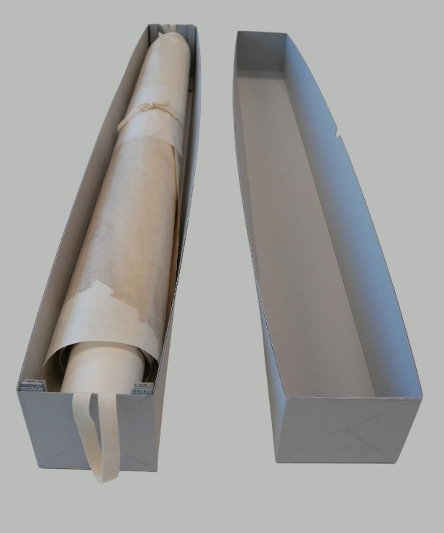
Instead, the map was rolled around a sturdy acid-free core, preventing it from becoming compressed or rolled too tightly. I then constructed a bespoke archival storage box from corrugated conservation board. Internal supports hold the ends of the core securely in place, preventing movement and providing much better protection during storage and handling.
After months of careful treatment, this remarkable six-metre map is now stable, better protected, and ready for future generations to explore. Although the railway route it records was never built, the document remains an important reminder of the many competing visions that helped shape Britain’s railway network.
Total conservation time 24.7 hrs
By Sophie Johns, Archivist and Sophie Coles, Archive Conservator
Refs:
- GREAT WESTERN RAILWAY. House of Lords Debate, 27 August 1835, vol 30 cc1012-261012. Lord Wharncliffe presented the Report from the Committee on the Great Western Railway Bill and moved that it be agreed to. GREAT WESTERN RAILWAY. (Hansard, 27 August 1835)
- MacDermot, E. T. and C. R. Clinker (1927) The History of The Great Western Railway 1833-1863, Volume One. Ian Allan: London.
The Conservation and Museums Advisory Service (CMAS) aims to promote excellence in the care and use of collections by providing conservation advice and practical treatments to heritage organisations and the public. We also support museums in Wiltshire to meet professional standards and become sustainable, resilient organisations.
If you have a conservation query, want a quotation to carry out some work, or would like to book a free appointment for one of our conservation surgeries, we would love to hear from you! You can contact the team by email cmas@wiltshire.gov.uk.
Visit our LinkedIn page https://www.linkedin.com/company/conservation-and-museum-advisory-service to see more examples of projects we’ve worked on.
CMAS
Contact us
E: cmas@wiltshire.gov.uk
T: 01249 705500
For all conservation enquiries including quotations and object deliveries, please book an appointment in advance.


